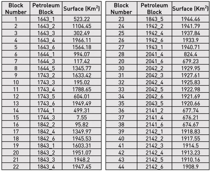
Available blocks
44 offshore blocks with a total acreage of the 63,296 km² in the Morondava Basin will be open for bidding. Each rectangular block size is about 1,940 km².

Offered Blocks Coordinates

Data Availability and Access
Seismic Data
 The offshore Morondava basin is covered by regional 2D seismic data. Vintage seismic data has been reprocessed through multiclient surveys with TGS, Spectrum, CGG Geospec and ION.


For more information, please see: Spectrum_Data_examples_Madagascar2018_licensing_round
Well Data
Six (6) exploration wells are located in the offshore Morondava basin:
- Chesterfield-1, water depth 28m
- Heloise-1, water depth 27m
- Morondava-1, water depth 32m
- Vaucluse-1, water depth 42m
- Eponge-1, water depth 20m
- Morombe-1, water depth 34m
Gravity and Magnetic

Reports and Other Data

Mandatory Data Package
Content:
- SEGYs of reprocessed regional TGS keylines (re-processed vintage seismic)
- Geotiffs of gravity and magnetic anomaly and residual maps
- Well data of relevant wells offshore and onshore
- Overview/interpretation TGS report Morondava west
Content – Itemisation

Content – Seismic included in the datapack, item #1 (map of seismic key lines)

Content – Wells included in the datapack, item #4 (map of relevant wells)
- 6 shallow water offshore wells in the Morondava Basin. Reports and Data. 5K per well
- Chesterfield-1, water depth 28m, is located 0.64km away from the nearest seismic line (MWM13-ST02)
- Heloise-1, water depth 27m, is located approximately 1.5km away from the nearest seismic line (MWM13-DL20), approx. 20km from keyline R5362-MB
- Morondava-1, water depth 32m, is located approximately 20km away from the nearest seismic line (R1005-MA), approx. 55km from keyline R5240-MB
- Vaucluse-1, water depth 42m, ties with line R1005-MA, approx. 9km from keyline R5240-MB
- Eponge-1, water depth 20m, is located approximately 5km away from the nearest seismic line (R1002-MA), approx. 16km from keyline R5320-MB
- Morombe-1, water depth 34m, ties with lines R1001-MA and R1003-MA, approx. 20km from keyline R5360-MB
- 3 onshore wells within close proximity to the block area and 2 DSDP boreholes west of the area. Well with logs only. Borehole info cleaned up. 5K per well, 750 per borehole.
- Ankamotra-1 located approx. 60km away from the nearest TGS offshore seismic line
- DSDP Leg 243 and 244
- Cap St Andre-1 located 51km and 45km away from the nearest seismic line (R1007-MA)
- Cap St Andre-2 located 51km and 45km away from the nearest seismic line (R1007-MA)
TOTAL 9 wells plus 2 DSDP boreholes
- 6 x data and reports
- 3 x logs only
- 2 x borehole data

Access to the data
- Data viewings are available at TGS offices in London and Houston
- Road Shows are available in London and Houston


